


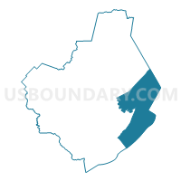
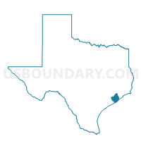
Voting District 0038, Brazoria County, Texas
About
Outline

Summary
| Unique Area Identifier | 671040 |
| Name | Voting District 0038 |
| County | Brazoria County |
| State | Texas |
| Area (square miles) | 209.15 |
| Land Area (square miles) | 88.60 |
| Water Area (square miles) | 120.55 |
| % of Land Area | 42.36 |
| % of Water Area | 57.64 |
| Latitude of the Internal Point | 29.07975660 |
| Longtitude of the Internal Point | -95.17316750 |
Maps

Graphs
Select a template below for downloading or customizing gragh for Voting District 0038, Brazoria County, Texas


Neighbors
Neighoring Voting District (by Name) Neighboring Voting District on the Map
- Voting District 0006, Brazoria County, TX
- Voting District 0008, Brazoria County, TX
- Voting District 0015, Brazoria County, TX
- Voting District 0017, Brazoria County, TX
- Voting District 0044, Brazoria County, TX
- Voting District 0054, Brazoria County, TX
- Voting District 0221, Galveston County, TX
- Voting District 0226, Galveston County, TX
- Voting District 0258, Galveston County, TX
Top 10 Neighboring County Subdivision (by Population) Neighboring County Subdivision on the Map
- Texas City-League City CCD, Galveston County, TX (217,765)
- Alvin-Pearland CCD, Brazoria County, TX (176,301)
- Brazosport CCD, Brazoria County, TX (60,212)
- Galveston CCD, Galveston County, TX (48,726)
- Angleton CCD, Brazoria County, TX (43,846)
- La Marque-Hitchcock CCD, Galveston County, TX (22,401)
Top 10 Neighboring Place (by Population) Neighboring Place on the Map
- Alvin city, TX (24,236)
- Hitchcock city, TX (6,961)
- Surfside Beach city, TX (482)
- Quintana town, TX (56)
Top 10 Neighboring Unified School District (by Population) Neighboring Unified School District on the Map
- Alvin Independent School District, TX (86,711)
- Brazosport Independent School District, TX (61,787)
- Galveston Independent School District, TX (50,606)
- Angleton Independent School District, TX (38,961)
- Santa Fe Independent School District, TX (24,183)
- Hitchcock Independent School District, TX (8,599)
- Danbury Independent School District, TX (4,331)
Top 10 Neighboring State Legislative District Lower Chamber (by Population) Neighboring State Legislative District Lower Chamber on the Map
- State House District 24, TX (181,472)
- State House District 23, TX (144,933)
- State House District 25, TX (141,704)
Top 10 Neighboring State Legislative District Upper Chamber (by Population) Neighboring State Legislative District Upper Chamber on the Map
Top 10 Neighboring 111th Congressional District (by Population) Neighboring 111th Congressional District on the Map
Top 10 Neighboring Census Tract (by Population) Neighboring Census Tract on the Map
- Census Tract 7235.02, Galveston County, TX (8,883)
- Census Tract 6644, Brazoria County, TX (6,591)
- Census Tract 6624, Brazoria County, TX (5,637)
- Census Tract 6641, Brazoria County, TX (5,348)
- Census Tract 7236, Galveston County, TX (4,306)
- Census Tract 7261, Galveston County, TX (2,935)
- Census Tract 6617, Brazoria County, TX (2,767)
- Census Tract 6642, Brazoria County, TX (1,916)
- Census Tract 9900, Brazoria County, TX (0)
- Census Tract 9900, Galveston County, TX (0)
Top 10 Neighboring 5-Digit ZIP Code Tabulation Area (by Population) Neighboring 5-Digit ZIP Code Tabulation Area on the Map
- 77511, TX (46,627)
- 77515, TX (30,309)
- 77541, TX (17,412)
- 77510, TX (13,731)
- 77563, TX (9,103)
- 77534, TX (2,863)